Algonquin Park is one of the best provincial parks in Ontario! Plus, it’s one of the most popular parks in Canada! This beloved park has so much to offer visitors. Along with the long list of Algonquin Park trails, there’s camping, a museum and art gallery, and more!
So, if you’re looking to visit Algonquin Provincial Park, I’ve got the guide for you! In this guide you’ll learn about the park, the best trails in Algonquin Park, other things to do, when to visit, and more!
About Algonquin Park
In the 1800s the landscape of the Algonquin Highland started to see big changes when pioneer loggers descended on the area. Established in 1893, Algonquin Park is the oldest provincial park in Canada. Oddly, the park was protected not to stop logging, but instead to create a wildlife preserve. The designation was also to protect the five major rivers found in the park and to prevent agriculture within its boundaries.
Algonquin Park covers 7,635 square kilometres! That’s larger than Prince Edward Island! As one of the largest Ontario parks, its landscape is varied. The park is home to over 1500 lakes as well as rivers, bogs, and forests. Plus, because of where the park is located, it is considered the transition zone between the coniferous forests of the north and the deciduous forests of the south. Researchers also say that many of the trees in Algonquin’s old-growth forests are over 400 years old. The result is a healthy mix of habitats for a wealth of wildlife and plant life. Algonquin Park is home to over 50 species of mammals, over 270 bird species, as well as over 1000 plant species and over 1000 species of fungi!
The park is also a National Historic Site of Canada because it protects various heritage values, which include its visitor programs that inspired many other parks in Canada, its role in park management techniques, as well as its part in inspiring artists, and more!
10 Best Trails in Algonquin Park
Covering such a massive space, there are over 20 Algonquin Park trails! With so many to choose from I’ll break down the best trails in Algonquin Park. In this trail guide you’ll learn what to expect on each hike, where it is, the length, and the best time to visit. Plus, who can resist a visit to one of the best places to visit in Ontario!
Pro Tip: Pop into the West Gate for a copy of the Algonquin Park trails map to find more information on programs, services, and more. It also has a a great map showing where all the trails are along the highway.

Mizzy Lake Trail
One of the best Algonquin Park trails is Mizzy Lake Trail! If you are keen to see wildlife in Algonquin, this is the trail! It’s also the longest trail along the Highway 60 corridor.
The Mizzy Lake Trail is located along the Highway 60 corridor. This roughly 11-kilometre loop trail takes between 4 and 6 hours and is considered moderate to difficult.
You’ll want to start early to enjoy this full day trail for a couple of reasons. At over 10 kilometres, the trail is long and has many ups and downs. There are a few flat sections, including a stretch along an abandoned railbed. It’s also full of incredible boardwalks making it one of the top boardwalk trails in Ontario!
Travelling around nine different small lakes and ponds, chances of spotting a myriad of wildlife is high! However, as many species are more active in the mornings, you’ll want to start as early as you can to optimize the chances of seeing wildlife.
Wolf Howl Pond is home to over 100 turtles! Check for logs to catch them basking. Mizzy Lake trail is also one of the best places to see Moose in Algonquin! Especially at West Rose Lake in June or July. Another beloved mammal found in the park is the otter. One of the best places to see otters in Algonquin is at Mizzy Lake itself!
Pro Tip: The trail is often very muddy, even beyond rainy days. So, be sure to wear proper water-resistant footwear. Also, consider packing a change of socks and shoes in the car.
Check out my 15 Hiking Must-Haves: Packing List for a Day Hike
Length: 11 km
Difficulty: Moderate
Access Point: at km 15.4 along Highway 60 corridor

Hardwood Lookout Trail
For those looking for a great view or a short trail in Algonquin, head to the Hardwood Lookout Trail! This short and moderately easy trail offers a scenic lake view.
The Hardwood Lookout Trail is located along the Highway 60 corridor. This roughly 1-kilometre loop trail takes approximately 30 minutes and is considered moderate.
Wandering through towering hardwood forest, this is a great trail to learn about some of the amazing trees that are found within the park. Pick up a trail guide at the trailhead. The guide shares interesting information about how different trees grow, the wildlife found within hardwood forests, and more.
At the peak, visitors will find a perfect bench to sit and take in the view over Smoke Lake and the surrounding hills of maples. Plus, behind the bench is a historical cairn. The cairn is pays tribute to Douglas McDonald Hains and his conservation work with Canada’s resources.
Pro Tip: Don’t miss the second trail found at the east end of the parking lot. The Red Spruce Side Trail brings you into a small stand of Red Spruce. This is one of the few pockets of Red Spruce found here in Ontario!
Length: 0.8 km
Difficulty: Moderate
Access Point: at km 13.8 along Highway 60 corridor
Centennial Ridges Trail
One of the best trails in Algonquin Park for fall colours is Centennial Ridges Trail! While it’s a long and challenging hike, it’s also one of the most popular thanks to the views.
The Centennial Ridges Trail is located along the Highway 60 corridor. This 10-kilometre loop trail takes between 4 and 6 hours and is considered moderate to difficult.
Be sure to wear proper footwear for this hike! Centennial Ridges is a rugged trail with many inclines. However, all your hard work is rewarded with a number of awesome views! The trail travels along two high ridges. You’ll find clifftop views over large swatches of forest and lakes, which are epic in the fall!
Length: 10 km
Difficulty: Moderate to Difficult
Access Point: at km 37.6 along Highway 60 corridor
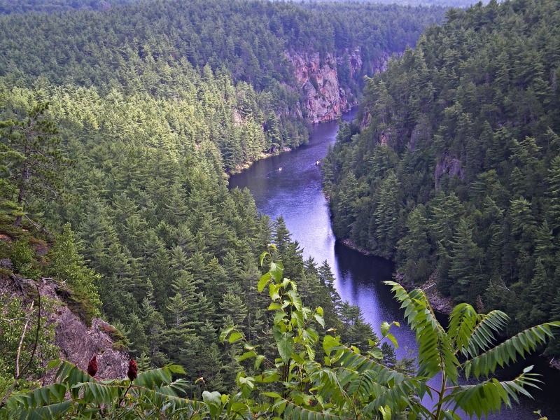
Barron Canyon Trail
Another of the top Algonquin Park trails is the Barron Canyon Trail! This trail is further afield and located within the Eastern Section of Algonquin.
The Barron Canyon Trail is located in the Eastern Section of Algonquin. This 1.5-kilometre trail takes roughly 1 hour and is considered moderate.
After a steep incline hikers will find a lookout over the Barron Canyon. Here, you’ll find a bench to catch your breathe and take in the view. Continuing along the ridge you’ll find more views of the Barron River as it carves it way through the spectacular canyon.
Please note that the trail runs along a cliff that is unfenced and has a drop of over 300 feet.
Pro Tip: If you want to experience the Barron Canyon from a different perspective then grab your canoe! You can canoe the river via the Brigham Lake or Barron River parking lots.
Length: 1.5 km
Difficulty: Moderate
Access Point: in Eastern Section, 11 km west of Sand Lake Gate
Hemlock Bluff Trail
I’m not bluffing when I say that for a great lake trail head to Hemlock Bluff Trail! Joking aside, this lovely trail’s top draw is the view of Jack Lake!
The Hemlock Bluff Trail is located along the Highway 60 corridor. This 3.5-kilometre trail takes roughly 2 hours and is considered moderate.
The trail takes you through the forest and up to a lovely view over Jack Lake. You’ll also find boardwalks and stairs taking you over tricky and muddy portions. After you descend the bluff you’ll find yourself along the water’s edge of the lake.
Pro Tip: The parking lot is on the south side of the Highway and the trailhead is on the north side of the road.
Length: 3.5 km
Difficulty: Moderate
Access Point: at km 27.2 along the Highway 60 corridor
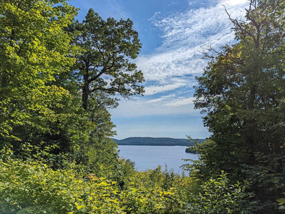
Lookout Trail
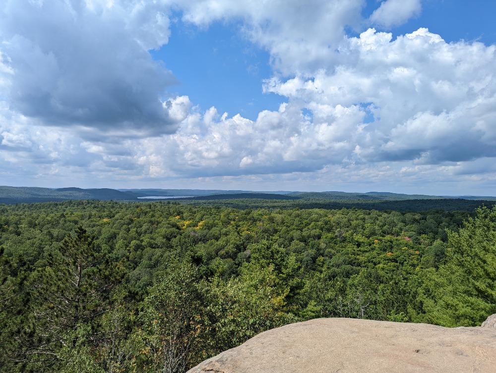
One of the most epic views of Algonquin Park is found along the Lookout Trail! This is an amazing hike anytime of year! In the summer the views of a lush green. In the autumn the views are awash in brilliant colours. And in the winter, it’s like looking out onto a magical frosty wonderland!
The Lookout Trail is located along the Highway 60 corridor. This 2.1-kilometre trail takes roughly 1 hour and is considered moderate.
Close to the trailhead the trail forks. Stick to the right and follow the markers. The trail is quite steep and rugged. Don’t fret, as you’ll be astounded with the awesome view that stretches for several hundred square kilometres over the park.
Pro Tip: If you’re hiking Algonquin Park’s Lookout Trail in the winter be prepared for the steep incline and decline. I recommend ice spikes if there’s any ice.
Length: 2.1 km
Difficulty: Moderate
Access Point: at km 39.7 along Highway 60 corridor
Track and Tower Trail
For one of the best trails in Algonquin head to the Track and Tower Trail! This trail shares a wealth of Algonquin Park history, especially in regards to the railroad that once passed through.
The Track and Tower Trail is located along the Highway 60 corridor. This 7.5-kilometre trail takes roughly 3 hours and is considered moderate to difficult.
Noted as another popular fall hike in Algonquin, the Track and Tower Trail offers sweeping views over Cache Lake. The trail travels over bridges, through dense forest, and by Grant Lake. Along the trail hikers can see various remains of the park’s railway. There are remains of an old trestle and the location of the former Skymount fire tower.
You can also add on an optional 5.5 km side trail that runs along the old railbed to Mew Lake.
Length: 7.5 km
Difficulty: Moderate
Access Point: km 25 along the Highway 60 corridor

Whisky Rapids Trail
One of the most overlooked Algonquin Park trails is the Whisky Rapids Trail. I’m not sure if it’s because there is no epic lookout but in my opinion it’s one of the best hiking trails in Algonquin. Plus, generally there are few people on it, so you’ll have it mostly to yourself!
The Whisky Rapids Trail is located along the Highway 60 corridor. This 2.1-kilometre loop trail takes roughly 1.5 hours and is considered moderate.
The trail travels along the Oxtongue River and out to Whiskey Rapids. This is a great trail for birding! There are numerous views along the river where you can catch kingfishers diving in. If you pick up a trail guide, you’ll learn interesting information about the ecology of the river and its history.
One fun factoid shares the story of how the Whisky Rapids got its name. It involves two log divers and their travels up the river with a keg of whisky. In the end the two paddlers were tanked and so was the keg!
Pro Tip: Before entering Algonquin Park stop at Oxtongue River-Ragged Falls Provincial Park to see Ragged Falls. It’s one of the top waterfalls in Muskoka!
Length: 2.1 km
Difficulty: Moderate
Access Point: km 7.2 along the Highway 60 corridor

Spruce Bog Boardwalk
One of the best Algonquin Park trails for birding is the Spruce Bog Boardwalk! The best part is that the trail is great in every season!
The Spruce Bog Boardwalk Trail is located along the Highway 60 corridor. This 1.5-kilometre trail takes roughly 1.5 hours and is considered easy.
Noted as one of the best boardwalk trails in Ontario, Spruce Bog Boardwalk is famous for its Gray Jays (also known as a Canada Jay) and chickadees. Many will even land on your hand if you are patient and hold it out. The trail is a short loop that takes you through two northern Black Spruce bogs that are ideal bird watching throughout the year.
Length: 1.5 km
Difficulty: Easy
Access Point: at km 42.5 along the Highway 60 corridor
High Falls Hiking Trail
I couldn’t resist adding another of trail that leads to one of the Algonquin Park waterfalls! High Falls is the tallest waterfall in the park!
The High Falls Hiking Trail is located in the Southern Section of Algonquin. This 4-kilometre trail takes roughly 1 hour return and is considered moderate.
From the trailhead, the trail travels along an old road taking you through a Red Pine plantation. Then you’ll traverse a footpath through the forest. Not to be confused with the High Falls in Bracebridge, this waterfall is on the York River.
One thing to note is that the trail is rocky in areas. Plus, along the trail are various caves and crevices, so be sure to stay on the trail.
Length: 4 km
Difficulty: Moderate
Access Point: at High Falls parking area off of Elephant Lake Road, across the road from Deep Roots Adventure
5 More Awesome Algonquin Park Trails
One thing that many are unaware of is the different sections of Algonquin Park. Most people explore the trails along the Highway 60 corridor. However, there is a Northern and Southern section of the park that has more trails to hike!
Two Rivers Trail
A great place for a mix of environments when hiking Algonquin Park is the Two Rivers Trail. This trail offers tranquil forest trails and cliff top views.
The Two Rivers Trail is located along the Highway 60 corridor. This 2.1-kilometre loop trail takes about 1 hour and is considered moderate to difficult.
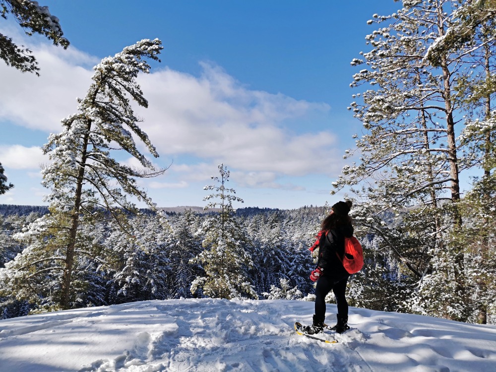
From the trailhead you’ll walk through part of Algonquin’s young forest. Taking you through towering trees, this is a one of the best Algonquin Park trails to hike in the winter. It’s a true winter wonderland! Then the trail gradually climbs.
At the top of the cliff, you’ll find a few iconic wind-swept pines and epic viewpoints over endless forest. Plus, one lookout gives you a view over the river!
Length: 2.1 km
Difficulty: Moderate
Access Point: at km 31 on the Highway 60 corridor
Booth’s Rock Trail
Another of the best trails in Algonquin Park for fall colours is Booth’s Rock Trail! With sweeping lake views and epic lookouts of forests draped in fall foliage, add this one to your Ontario fall hikes bucket list!
The Booth’s Rock Trail is located off the park’s Highway 60 section. This 5.1-kilometre trail takes between 2 and 3 hours and is considered moderate to difficult.
This trail has a lot of incredible features! After a steep climb you’ll find yourself on a ridge with views of Rock Lake. Along the ridge are a number of awesome lookouts! Plus, after coming down off the ridge you’ll find the ruins of the Barclay Estate. This once grand estate was home to J.R. Booth, a logging tycoon. The trail back follows an abandoned railway line.
Length: 5.1 km
Difficulty: Moderate to Difficult
Access Point: via km 40.3 of Highway 60, off of Rock Lake Road
Logging Museum Trail
For those looking for an easy and accessible trail where you can learn about the park’s history then hike the Logging Museum Trail!
The Algonquin Logging Museum Trail is located on the park’s Highway 60 section. This 1.3-kilometre loop trail takes about 1 hour and is considered easy.
Along the trail hikers will find exhibits that help share park’s logging history, from the 1830’s to now. The trail has a numerous fun sights relating the logging! There’s a reproduction of a camboose camp, a log chute, and something called an ‘alligator.’ The alligator is a steam-powered tug that’s amphibious.
Length: 1.3 km
Difficulty: Easy and accessible
Access Point: via Algonquin Logging Museum at Highway 60’s 54.5 km marker.

Peck Lake Trail
A lovely scenic hike in Algonquin Park is the Peck Lake Trail. The trail travels around Peck Lake’s shoreline.
The Peck Lake Trail is located along the Highway 60 corridor. This 1.9-kilometre loop trail takes about 1 hour and is considered moderate to difficult.
This is a classic lake on the Canadian Shield hike! As the trail winds around the lake, you’ll find peak-a-boo lookouts of the lake. In addition, you’ll find short boardwalks and stretches that take you out onto rocky outcroppings along the water’s edge. It’s a great hike to do at midday as you’ll find plenty of shade along the forested trail. Plus, there are plenty of spots to sit and enjoy a picnic by the water.
Length: 1.9 km
Difficulty: Moderate
Access Point: at Highway 60’s km 19.2
Brent Crater Trail
One of the most fascinating Algonquin Park trails leads to one of the most famous fossil meteorite craters in the world! Yes, Algonquin is home to a crater from a meteorite!
The Brent Crater Trail is located in the park’s northern section. This 2-kilometre loop trail takes about 1.5 hours and is considered moderate to difficult.
Thousands of years ago a meteorite crashed and formed what is now known as the Brent Crater. The trail offers views of the crater from a wooden observation tower. Plus, the trail will also take you down to the floor of the crater. In addition, along the trail hikers will find six interpretive stops where you’ll learn interesting facts concerning the crater, both geological and historical.
Length: 2 km
Difficulty: Moderate to Difficult
Access Point: via Brent Campground
Other Algonquin Park trails: Bat Lake Trail, Big Pines Trail, Beaver Pond Trail, Berm Lake, Jack Pine Trail, Scorch Lake Lookout Trail, and Bruton Farm Hiking Trail.

Best Time for Hiking Algonquin Park
Many ask when is the best time to hike Algonquin Provincial Park. There is no right answer. It all depends on what you want and expect.
Winter – If you love cooler temperatures and fewer crowds then the best time to hike Algonquin is in the winter! Who can resist a hiking in a winter wonderland and views of snow-covered trees?! Plus, winter in Algonquin means no bugs! Winter also means you can enjoy cross country skiing and attend the Winter in the Wild Festival. However, some trails or parking lots may be closed. Be sure to check local weather conditions before heading out.
Spring – Spring is a great time to visit Algonquin for various reasons. Spring means more comfortable temperatures. Plus, it’s a wonderful time to experience all of the wildflowers that spring up across the park. Spring is also prime moose spotting!
Summer – One of the best times to hike Algonquin Park is during the summer! Sunshine, warm temperatures, and lush foliage brings out many hikers to the park. However, prime hiking season means more crowds, plus you’ll have to contend with bugs.
Fall – The best time to visit Algonquin is the fall! The park is one of the best places to enjoy fall colours in Ontario! Plus, autumn means more comfortable temperatures and no bugs. With a wealth of sugar maples and hiking trails with lookouts overlooking brilliant fall foliage, fall is the busiest time to visit. So, try and plan to visit during the week to avoid weekend crowds.
Pro Tip: You can reserve your park permit up to 5 days in advance. So, book ahead to visit during the fall!
More Fun Things to do in Algonquin Provincial Park
Beyond all the awesome Algonquin Park trails there are so many more activities to enjoy! If you’re looking for more things to do in Algonquin Park, you’ll find a diverse list below. Along with outdoor adventures like camping and paddling, the park is also home to cultural attractions too!
Camping
One of the most popular parks in Ontario for camping is Algonquin! There are eight campgrounds along the Highway 60 corridor and a few others elsewhere in the park.
Campers can choose from drive to campgrounds or backcountry camping. Plus, for those adventurous campers, there is year-round camping available at the Mew Lake Campground.
For those who want to experience the park but looking for a more comfortable camping experience, there’s something for you too! Algonquin Park is also home to yurts, cabins and lodges!
Algonquin Visitor Centre
To mark the 100th anniversary of Algonquin Park they opened the visitor centre. The Visitor Centre is a great place to learn more about the park. Inside you’ll find numerous exhibits that showcase the natural and human history of the park. And it’s open year round, including most holidays!
There’s also a theatre where you can watch a presentation about park. In addition, the centre is home to one of the Algonquin Park bookstores as well as a café.
One of the biggest attractions is the Visitor Centre lookout! There’s a viewing deck where you can take in a sweeping view from atop one of the park’s ridges!
Paddling
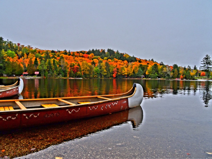
With its massive size, approximately 15% of Algonquin Park is made up of water. The park’s lakes and rivers make up some of the best canoe routes in Ontario.
The canoe route network is made up of an astounding over 2,100 km! If you do plan to paddle Algonquin, be sure to pick up a Canoe Routes map. The map features routes, portages, backcountry campsites as well as access points.
Two great canoe routes in Algonquin Park are Canoe Lake to Burnt Island Lake and Barron Canyon!
If you don’t have a device, you can rent a canoe and gear from The Portage Store, Algonquin Outfitters, and Opeongo Outfitting Store. All of which are found along Highway 60 in the park.
Algonquin Art Centre
Algonquin Park has and continues to inspire artists from around the world! Some of which went on to become the iconic Group of Seven. So, it’s no surprise that the park is home to an incredible art centre.
Perched on a hillside beside Found Lake is where you’ll find the Algonquin Art Centre. It’s home to an indoor gallery, an outdoor gallery and a shop. Plus, it hosts a variety of art activities for all ages. The gallery features awesome Canadian artists, with art showcasing the natural world including wildlife! Every year there the gallery adds new works to keep you coming back!
Algonquin Art Centre is open daily 10am to 5pm between June 1 to mid-October.
Algonquin Logging Museum
Another interesting place to learn more about the history of Algonquin Park is the Logging Museum! At the museum visitors will find exhibits as well as a diorama focusing on the park’s history of logging and forestry practices.
The Algonquin Logging Museum has a great video sharing Algonquin’s logging history. Plus, one of Algonquin’s interpretive walking trails, Logging Museum Trail, provides even more insight.
Winter in the Wild Festival
While many people visit the park in the summer, be sure to add Algonquin’s Winter in the Wild Festival to your Muskoka in winter bucket list! The annual festival takes place on the Family Day weekend and features a ton of fun winter activities in Algonquin Park!
A few of the events include guided bird walks, snowshoe trips, winter camping demonstrations, and so much more! Winter in the Wild Festival helps visitors gain a new appreciation of the park!
Cross-country (Nordic) Skiing
Hiking Algonquin Park trails is only one of the many activities you can enjoy in the park!
Algonquin Park is home to 85 kms of groomed cross-country ski trails along with over 30 kms of non-groomed trails. Skiers will find trails with varying difficulty, so there’s something for everyone!
A great cross-country skiing trail in Algonquin is the Fen Lake Ski Trail! The trail is located at the West Gate and takes skiers through hardwood forests. There are four different loop options to choose from, ranging from just over 1 kilometre to 13 kms.
Two other ski trails in Algonquin are Minnesing Trail and Leaf Lake Ski Trail. Both also offer varying lengths and travel through different terrain.
Ski trails in Algonquin Park generally open in December and close in March. However, these dates depend on weather conditions.
Tom Thomson Plaque
For everyone who follows me, you know I am a huge Group of Seven fan! If you are too then be sure to visit the Tom Thomson plague in Algonquin Park, one of the many Group of Seven locations in Ontario!
Dare I say that he was one of Algonquin Park’s first influencers, with his “platform” being his incredible art. Many of his pieces showcase the natural beauty of the park, including The Jack Pine.
One of his favourite places was Canoe Lake, where he sadly died in 1917. Now, a plaque dedicated to Thomson sits at the Visitor Centre dock on Canoe Lake.
Fun Fact: Tom Thomson was a guide in the park!
Biking
Another fun activity in Algonquin Park is cycling! You can cover more ground and explore other Algonquin trails. Plus, if you don’t have a bike, you can rent bikes from Algonquin Outfitters.
There are three main bike trails in Algonquin Park: Old Railway Bike Trail, Minnesing Mountain Bike Trail and Byers Lake Mountain Bike Trail.
Old Railway Bike Trail is 16 km and great for all ages and abilities. The trail runs along an old railway line that travelled between Ottawa and Parry Sound.
Minnesing Mountain Bike Trail is rugged and ideal for mounting biking. It travels through forests, along boardwalks, and by lakes and streams. You can choose the loop length, either 4.7 km or 23.4 km.
Byers Lake Mountain Bike Trail is another rugged trail. The trail is 6.5 km out and back and takes cyclists over various terrain. Plus, there’s views of the York River, Byers Lake, and Gut Rapids.

Frequently Asked Questions about Visiting Algonquin Park
To help you plan your hiking trip to Algonquin Park I’ve round up a few of the top questions about Algonquin.
Where is Algonquin Provincial Park? – Algonquin Park is located in the Unorganized South Nipissing District. It’s approximately 1 hour east of Huntsville and 3.5 hours north of Toronto. The park is set on the Canadian Shield, 3 hours northwest of Ottawa.
Which Algonquin trail is the best? – Many say the Centennial Ridges Trail is the best trail in the park. However, I think it’s a tie between Centennial Ridges and the Lookout Trail.
How many hikes are in Algonquin Park? – There are 21 hiking trails in Algonquin Park. In addition, there are over 140 km of backpacking trails.
Do you need a permit to hike in Algonquin? – Yes, you need a valid park permit to hike Algonquin. Day vehicle permits can be purchased online here, up to 5 days in advance. You have to choose your entry point, Highway 60 (the most popular), Achray/Sand Lake Gate, Brent, Kingscote, Kiosk, Shall, or Tim River. Highway 60 permits are $21/day. Other locations are $18/day.
Can you just drive through Algonquin Park? – Yes, you can drive through Algonquin Park along Highway 60 for free. It is a very scenic drive, especially in the fall! However, if you want to stop at any of the park’s amenities, like trails or bathrooms, you need a permit.
What’s the best time of year to see the maple leaf colour change? – Typically, the best time to view the colour change of sugar maple trees is the last week of September and into the first week of October. However, it depends of various weather conditions. But peak fall foliage in Algonquin is usually between mid-September to mid-October.
Other Ontario Parks Guides
Killbear Provincial Park Trails
PIN IMAGE FOR LATER REFERENCE!